


Widespread winter weather alerts and warnings affect over 100 million Americans today as multiple storm systems create challenging conditions across the United States. The National Weather Service has issued warnings spanning from Colorado to Maine, with significant snowfall reaching 9 inches in West Virginia and disrupting scheduled activities in Washington, D.C.
Weather forecasts indicate a series of three storm systems will maintain winter conditions over affected regions. Maryland could receive up to 6 inches of snow, while New York City expects 1-2 inches. The South faces different challenges, with heavy rainfall from east Texas to southern Kentucky putting 15 million people under flood alerts. Additionally, 10 million residents from Birmingham, Alabama to Baton Rouge, Louisiana face potential tornado risks.
Air travel disruptions are already evident, with approximately 200 delays and 70 cancellations reported on the East Coast since early morning. A second storm system developing over eastern Colorado and the Plains is projected to bring substantial snowfall to the Midwest and Upper Midwest regions. Cities like Chicago, Milwaukee, Grand Rapids, and Detroit may experience snowfall rates of one inch per hour, potentially affecting evening commutes and causing school closures.
Specific snowfall predictions include 4-7 inches for Chicago, 4-6 inches for Detroit, and 3-6 inches for Kansas City through Thursday night. Officials have deployed a 400-person snow team in Kansas City, closed City Hall, and canceled schools. Local authorities are advising residents to stay home when possible.
California braces for what could be its largest winter storm of the season, with an atmospheric river event threatening flooding and potential mudslides in wildfire-affected areas. The state government has implemented extensive preparatory measures, including deploying protective barriers, sandbags, fire engines, and personnel across eight counties.
Arctic air continues to impact the northern regions, with North Dakota experiencing wind chill temperatures as low as minus 55 degrees Fahrenheit. This cold front is expected to move southward, bringing temperatures 25-35 degrees below seasonal averages to the Ohio Valley and central Appalachians by Friday.
As Gulf moisture moves northward, the southeastern United States faces additional challenges with heavy rain, thunderstorms, and tornado risks. Meanwhile, the Pacific Northwest expects coastal rain and mountain snow as the winter weather system affects the entire Western region.


About the author

Anfield Evacuated Minutes Before Liverpool and Athletic Bilbao Match
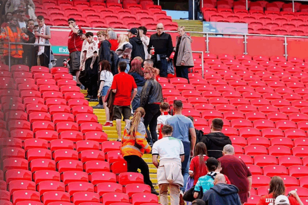
Liverpool's Anfield Main Stand was evacuated prior to their scheduled friendly match against Athletic Bilbao on Sunday. The fixture was set to kick off at 5:00 p.m., with a second match between the same teams planned for 8:00 p.m. Spectators were directed to leave the stadium immediately after an alarm activation, as they were taking their seats. Officials have not yet disclosed the reason for the evacuation. Spectators leaving the stadium The matches represent Liverpool's preparation for the new Premier League season, featuring a combination of first-team players and academy prospects across two separate games against the Spanish club. The squad for the opening fixture includes Darwin Nunez, Alexis Mac Allister, Curtis Jones, Harvey Elliott, Kostas Tsimikas, and Andy Robertson among the senior players selected. These friendlies mark Liverpool's return to Anfield following the tragic death of Diogo Jota. The […]

THOUSANDS Storm London Streets as Lionesses Victory Parade Takes Over Central London!
Thousands of supporters are expected to gather in central London on Tuesday for an open-top bus celebration following England's European Championship victory. The Lionesses secured their title defense through a penalty shootout victory against Spain in Basel, Switzerland, on Sunday. The celebration will feature the team and head coach Sarina Wiegman traveling along the Mall near Buckingham Palace shortly after midday, with fans lining the route. A trophy ceremony at the Queen Victoria Memorial will follow, hosted by former England player Alex Scott. The Football Association is organizing the free event and has advised attendees to plan carefully due to expected high attendance levels. FA Chief Executive Mark Bullingham expressed pride in the team's achievement, stating the celebration would allow fans to "be part of history" and create lasting memories. Celebrations began Monday afternoon when the team arrived at Southend […]
PM Calls Emergency Cabinet Meeting as Gaza Crisis Reaches Breaking Point
Prime Minister Sir Keir Starmer has scheduled an urgent Cabinet meeting for Tuesday afternoon to address the ongoing situation in Gaza and outline potential pathways toward peace. The meeting will bring together senior ministers during the summer parliamentary recess. During his recent meeting with US President Donald Trump in Scotland, Starmer discussed collaborative plans he is developing with France and Germany aimed at establishing lasting peace in the region. Downing Street confirmed these discussions took place at Trump's Turnberry golf course. The Prime Minister faces increasing pressure from parliamentarians to immediately recognize Palestinian statehood. Over 250 cross-party MPs have signed a letter urging the government to take this step, representing an increase from 221 signatures recorded on Friday. A spokesperson for the Prime Minister stated that this week's focus centers on creating "a pathway to peace to ensure immediate relief […]

Trump Opens Secret New Golf Course Before Air Force One Departure!
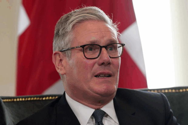
US President Donald Trump will inaugurate a new golf course at his Aberdeenshire resort on Tuesday, marking the conclusion of his five-day Scottish visit. The ribbon-cutting ceremony for the second 18-hole course at Trump International Scotland in Menie will precede his departure to the United States aboard Air Force One. Trump has participated in multiple golf rounds during his stay in Scotland, playing at his Turnberry resort in Ayrshire on Saturday, Sunday, and Monday. The Turnberry location also served as the venue for bilateral discussions between Trump and Prime Minister Sir Keir Starmer on Monday, followed by an extended press conference. Donald Trump and Keir Starmer During the press conference, Trump addressed various topics, including his relationship with Scotland. The Republican leader expressed his affection for the country, stating he possessed "great love" for Scotland and desired to see the […]

US Companies Face ‘Absolute Nightmare’ as Trump’s Trade Wall Hits!
President Donald Trump has implemented comprehensive tariff increases on imports since returning to office, beginning with Chinese goods and expanding to products from nearly all countries globally. The emerging economic landscape reflects the construction of extensive tariff barriers not seen in the United States for over a century. Since April, most imported goods face taxes of at least 10%. Additional tariff increases are scheduled to begin on August 1st, following the conclusion of temporary pauses on some planned levies. Trump has communicated planned tariffs to various countries through official letters and established agreements with major trading partners, including the European Union and Japan. These "frameworks" contain unresolved issues while implementing previously unprecedented levy structures. Current import taxes range from 10% to 50% based on country of origin, representing a significant increase from the average tariff rate of less than 2.5% […]
Cross-Country Killer Shoots Four Dead in Manhattan Massacre!
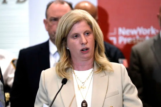
A 27-year-old Nevada resident has been identified as the suspect in a Manhattan office building shooting that left four people dead and multiple others injured on Monday evening. Shane Devon Tamura allegedly entered 345 Park Avenue in midtown Manhattan armed with an M4 rifle and opened fire in the lobby and on the 33rd floor before taking his own life. Shooter Shane Tamura entering the building with a rifle New York Police Commissioner Jessica Tisch confirmed that Tamura had recently driven across the country from Nevada to New York. Law enforcement partners in Las Vegas reported that Tamura had a documented mental health history, though his motives remain under investigation. Among the victims was Officer Didarul Islam, 36, who was working security at the building. The other three victims have not been publicly identified. One additional person was hospitalized in […]
Related
Anfield Evacuated Minutes Before Liverpool and Athletic Bilbao Match
Liverpool's Anfield Main Stand was evacuated prior to their scheduled friendly match against Athletic Bilbao on Sunday. The fixture was set to kick off at 5:00 p.m., with a second match between the same teams planned for 8:00 p.m. Spectators were directed to leave the stadium immediately after an alarm activation, as they were taking their seats. Officials have not yet disclosed the reason for the evacuation. Spectators leaving the stadium The matches represent Liverpool's preparation for the new Premier League season, featuring a combination of first-team players and academy prospects across two separate games against the Spanish club. The squad for the opening fixture includes Darwin Nunez, Alexis Mac Allister, Curtis Jones, Harvey Elliott, Kostas Tsimikas, and Andy Robertson among the senior players selected. These friendlies mark Liverpool's return to Anfield following the tragic death of Diogo Jota. The […]

Bolsonaro Supporters Rally Nationwide as Trump Sanctions Brazil Over Coup Trial
Supporters of former Brazilian President Jair Bolsonaro have demonstrated across major cities protesting the Supreme Court coup trial that could result in lengthy prison sentences for the former leader. Protesters gathered Sunday in São Paulo, Rio de Janeiro and other cities, carrying Brazilian and United States flags in apparent reference to President Donald Trump's support for his political ally. Demonstrators displayed banners featuring images of both Bolsonaro and Trump while chanting supportive slogans. Bolsonaro faces accusations of attempting to overturn the 2022 election results after losing to left-wing opponent and current President Luiz Inácio Lula da Silva. In January 2023, Bolsonaro supporters stormed Brazil's congress, ransacking chambers and attacking police in scenes reminiscent of the January 6, 2021 attack on the US Capitol by Trump supporters. According to testimony from a Brazilian general, the alleged plotters also planned to assassinate […]
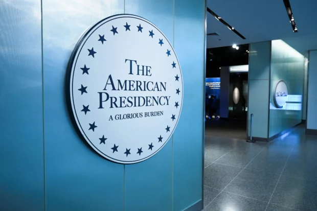
Smithsonian Museum Quietly Removes Trump Impeachment Display Sparking Political Firestorm
The Smithsonian Institution has denied political influence in its decision to remove a display about President Donald Trump's impeachments from the National Museum of American History. The institution stated Saturday that it removed the "temporary" placard for failing to meet museum standards regarding "appearance, location, timeline, and overall presentation." Officials explained the display was inconsistent with other exhibit sections and obstructed views of objects within its case. "We were not asked by any Administration or other government officials to remove content from the exhibit," the Smithsonian said in a statement. The institution, which operates 21 museums and the National Zoo, announced plans to update the impeachment section in coming weeks to "reflect all impeachment proceedings in our nation's history." The Washington Post reported Thursday that the museum removed explicit references to Trump's impeachments last month, leaving the exhibit incorrectly stating […]
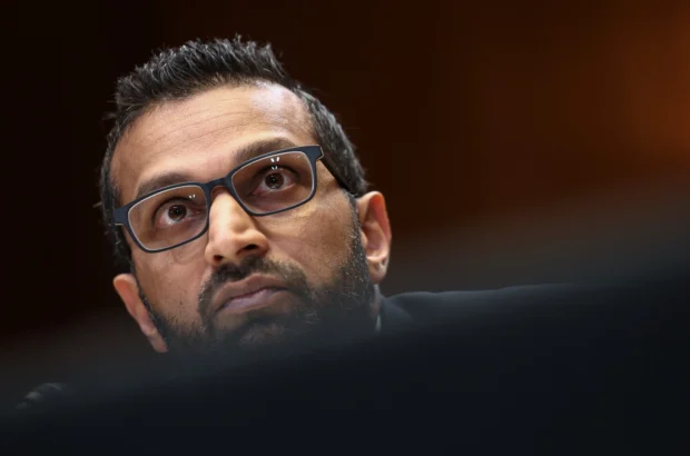
FBI Opens Major New Office in New Zealand to Counter China Threat
The Federal Bureau of Investigation has established a standalone office in Wellington, New Zealand, marking a significant expansion of US law enforcement presence in the Asia Pacific region. The move represents both countries' coordinated efforts to address Chinese influence across the region. FBI Director Kash Patel personally traveled to New Zealand to inaugurate the office, emphasizing the "strong relationship" between the FBI and New Zealand's law enforcement and intelligence agencies during Thursday's opening. Speaking in a video shared by the US embassy, Patel highlighted US-New Zealand collaboration on China-related issues as particularly significant. "Some of the most important global issues of our times are the ones that New Zealand and America work on together – countering the CCP [Chinese Communist Party] in the Indo PACOM theatre, countering the narcotics trade, working together against cyber-intrusions and ransomware operations and, most importantly, […]

NBA Star Gilbert Arenas Arrested For Running Million Dollar Poker Ring From Mansion
Former NBA All-Star Gilbert Arenas and five co-defendants face federal charges for allegedly operating an illegal gambling enterprise from his Encino, California mansion. The 43-year-old former guard is charged with conspiracy to operate an illegal gambling business, operating an illegal gambling business, and making false statements to federal investigators. He appeared for arraignment Wednesday afternoon in the United States District Court in downtown Los Angeles, facing a potential maximum sentence of five years in federal prison per count if convicted. Among those arrested Wednesday was 49-year-old Yevgeni Gershman, identified by the US Attorney's Office of the Central District of California as a suspected organized crime figure from Israel. According to the unsealed federal indictment, Arenas and his co-defendants operated the illegal gambling business between September 2021 and July 2022. Arenas rented his Encino mansion to co-conspirators who hosted illegal "Pot […]
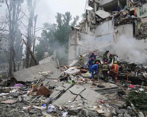
Russian Missiles Kill Six Including Child As Trump’s Peace Deadline Expires
At least six people were killed and more than 50 were wounded in a Russian drone and missile attack that hit multiple districts across Kyiv and collapsed an apartment building, Ukrainian officials reported. Among the fatalities was a six-year-old boy. Tymur Tkachenko, head of Kyiv's military administration, warned the death toll could increase, with damage reported at over two dozen locations throughout the capital. The distinctive sound of Russian drones was audible for hours over Kyiv, punctuated by the explosive impact of missile strikes. Despite the ongoing attacks, they have persisted even after US President Donald Trump threatened stronger sanctions against Moscow if Vladimir Putin fails to agree to a ceasefire by August 8. Ukraine's air force reported that Russia launched 309 drones and cruise missiles overnight. While air defense systems intercepted some incoming projectiles, numerous strikes found their targets, […]
Be the first to leave a comment